Tippecanoe County
Potawatomi Trail
While a timber harvest can look unsightly in the short term, we know that targeted harvesting promotes oak/hickory regeneration and herbaceous biodiversity, and regenerating hardwood forests sequester and store more carbon. Trees harvested will have their carbon stored via wood products. The increased herbaceous species diversity following the harvest will store more carbon in the soil via their dense roots. New oak trees will grow, sequestering more carbon over time. All this sequestered carbon plays an important role in mitigating the harmful global impacts of climate change while also improving ecosystem function at the local preserves.
For more information about the ecological benefits of timber harvesting, read our blog post: Restoring Oak Woodlands.
Potawatomi Trail sits between Ross Hills and Black Rock in Tippecanoe and Warren Counties. The tract of 59 acres brings NICHES closer to our goal of connecting Black Rock and Ross Hills into a permanently secured corridor for wildlife, plants and people to roam unhindered by development.
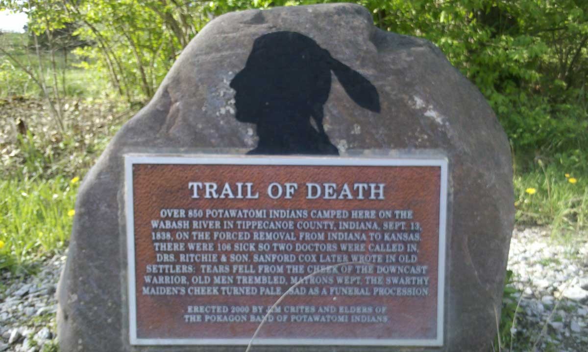
The Potawatomi Trail was named in memory of the forced emigration of the Potawatomi tribe from Indiana to Kansas in 1838. The tribe and their US government captors camped on the property September 13, 1838.
Activities
- Bird Watching
- Fishing
- Wildflowers
History of Acquisition and Property
In April of 2012, NICHES acquired Potawatomi Trail.
Prior to NICHES acquisition, the land had been enrolled in the Wetland Reserve Program, permanently retiring the ag land.
After acquiring, NICHES restored the upland acreage to a mix of native species.
How to Get There
From Lafayette/West Lafayette take South River Road/Division Road west across US 231 and follow that for 8.3 miles to the Ravines Golf Course at S 875 W and take a left. Follow S 875 W past Ross Hills Park and curve right onto W 50 S. Take the next left onto 925 W and follow that past Ross Camp and curve right again onto W 75 S. Take the next left onto S 950 W and follow that for 2.2 miles until you reach the sign at the southern edge of the property and park along the upland side of the road.
From Attica/Williamsport turn onto SR 55 from SR 28/41 and cross the bridge over Big Pine Creek. Take the first right onto E Independence Road. Follow Independence Road for 9.7 miles until you reach E 350 N and turn right. Follow E 350 N for 1.5 miles and park along the upland side of the road near the property sign.
Park along the road north of the property sign at the area marked in yellow.
Noteworthy Information
Park along the road north of the property sign at the area marked in yellow
Closures
Closed in November for Deer Control Hunt
Parking
No Lot. Use caution when parking along country road side. Do not block traffic
Number of Acres
59
1782 N 400 E, Lafayette, IN 47905
(765) 423-1605
niches@nicheslandtrust.org